Androzic

Navigation client that uses OziExplorer maps (ozf2, ozfx3). Great for hiking, geocaching, off-roading, sailing, boating and other outdoor activities. You are expected to be aware of OziExplorer or at least of where to get its maps. Maps also can be created by yourself, but with some afford, see FAQ for details. Can work without maps as a simple navigator.
Application features:
• map index, switch between maps, zoom, drag
• works without maps as a simple navigator
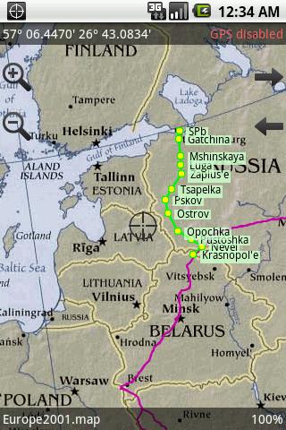
• show current position, speed, course, elevation
• look ahead
• show current track, write track into file
• track recording in background (power-safe)
• edit track, view track details
• full track support
• full waypoint support
• full route support
• convert track to route
• project new waypoint
• create new or edit existing route
• load and save data files in in native ozi format
• load waypoints, tracks and routes in KML and GPX format
• navigation to waypoint and via route
• HSI and compass displays
• units configurable
• load best scale map automatically
• load arbitrary map
• show map and user grids
• search coordinates in various formats
• search waypoints, tracks, routes
• search locations via Google geocoder
• trackball and D-pad support
• portrait and landscape modes
• configurable paths
NOTICE: if your map fails to open please send report.
BAD NEWS: current version of Img2Ozf generates ozfx3 maps in new format, they won't open in Androzic. Please use older versions of Img2Ozf, last known good version is 3.03.
App Specification
- App Name: Androzic
- Rating: 4.36
- Apk: com.androzic
- Cost: Free
- Developer: http://androzic.googlecode.com/